
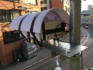
On a scaffold high above the heads of the pedestrians at Pilestredet 47c and 48 in Oslo, sophisticated measuring instruments spent a few weeks characterising air currents and measuring various types of air pollution. The instruments were part of a project run by NILU – Norwegian Institute for Air Research, to obtain data on air flow patterns and how air pollution is distributed vertically.
“Most of the pollution in the city streets is from vehicle traffic, and is emitted at street level”, says project manager and scientist Gabriela Sousa Santos. “Here, we want to analyse air flow patterns and find out how this air pollution moves and is diluted from ground level up to the rooftops of the buildings along a street.”
Streets that “capture” air pollution
Pilestredet, near Frydenlund tram stop, is an example of what scientists call an “urban canyon”, a stretch of road with relatively tall buildings on both sides. These tall buildings are part of what makes spreading conditions worse, because they prevent the wind from diluting the air pollution as efficiently as in more open urban landscapes.
The measuring instruments were in place for two weeks in early November 2019 and removed shortly after.
Instruments to measure wind speed and direction, temperature and relative humidity were placed on the roof of Pilestredet 48. The same kinds of measuring instruments were also mounted on different “floors” of the scaffold, along with instruments to measure components such as nitrogen dioxide (NO2), ground-level ozone (O3) and CO2.
In addition, the scientists inventoried traffic on Pilestredet, to obtain up-to-date information on how many different types of vehicles pass through on an hourly and 24-hour basis.
Models do not account for tall buildings
The objective of this campaign was to provide data for further development of different models for air flow and
air quality.
Sousa Santos explains that air quality dispersion models usually disregard buildings, and thus also streets. Furthermore, the rendering of topography is quite simplified and homogeneous, and the flow and dispersion around buildings is based on averages. For example, the models consider air flows above the height of the buildings as representative of the average wind in a city context.
Street-level concentrations of pollution are calculated using a Gaussian model developed by NILU, called EPISODE. It takes into consideration concentrations and distribution of various substances in the air, based on emission data, meteorological data and other factors. In addition, it defines how much of the pollution is emitted from each source and moves to a specific point, and then uses the average city-scale wind described above – without regard to buildings.
Data from Pilestredet will contribute to better modelling
The NILU scientists know, however, that the buildings in a city represent physical obstacles that play a crucial role in raising the level of pollution in the urban environment. This is especially true in urban canyons. There, air currents and eddies may develop, and provide very poor opportunities for diluting air pollution at street level.
“With these measurements, we hope to capture and characterise these episodes in terms of both flow patterns and pollution levels”, explains Sousa Santos. “Ultimately, we want to use the measurements to develop and validate models that include buildings.”
One of the models to be further developed using data from this campaign is the EPISODE-3D model. It is based on the EPISODE model described earlier, but it also includes buildings when it parameterises the air flow patterns.
Besides EPISODE and EPISODE-3D, NILU scientists use a computational fluid dynamics model (CFD) that explicitly includes buildings. The PALM model is a so-called large-eddy simulation model, which calculates the properties of turbulence and wind with very high spatial and temporal resolution. The PALM model is open source, and mainly developed at Leibniz University Hannover.
Now that the instruments have been dismantled, the task of analysing the collected data remains. In addition, the intention is to share the most relevant information with the people who live in the buildings where the measuring instruments were situated.
“We will complete the analysis of the observations and start using them to validate our models during 2020”, concludes Gabriela Sousa Santos.