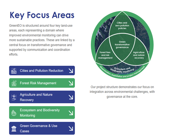
Project
Pesticides
Pesticides (plant protection products) are used to control damage to agricultural and forestry crops caused by fungi, pests and weeds.
Since the 1960s, concerns have been raised about the harmful effects that pesticides may have on the environment and human health, and the formerly used organochlorine pesticides (DDT, HCH og HCB) were therefore banned. As a consequence, more biodegradable replacement substances, so called CUPs (Currently Used Pesticides), have been developed.
Pesticides can be transported away from the areas where they are used, and it is known that pesticides are found in groundwater, surface water and soil. Pesticide content is also monitored in fruit and vegetables in Norway. However, little knowledge exists regarding exposure to people who are in and near areas treated with pesticides.
The project
This project will respond to knowledge gaps and areas of focus that are consistent with the current Action Plan for the Sustainable Use of Pesticides.
The purpose is to increase knowledge about the level of exposure for those who handle plant protection products and people who are in the vicinity of areas sprayed with pesticides. The focus is on the crop categories grain, potato and fruit.
Furthermore, the project aims to examine the conditions and capacities users have to reduce exposure that may be harmful to the health.
The project is led by Norwegian Institute of Bioeconomy Research (NIBIO), and in collaboration with The National Institute of Occupational Health (STAMI), RURALIS Institute for Rural and Regional Research, and NILU, both air and surface samples will be taken, and exposure among farmers and other users of will be recorded. The study areas selected include a fruit-growing area in Ullensvang, a grain area in Romerike and a potato growing area along the Glomma in Grue municipality.
NILU
NILU, headed by Helene Lunder Halvorsen, is responsible for sampling air and surfaces.
The level of pesticides in the air will be examined in areas where the general public can typically be exposed, such as schools, kindergartens and sports fields. During the growing season (April-September) in 2025 and 2026, monthly air samples (1 week) will be taken with an active air sampler (Kleinfiltergerät, see picture), using a pump to collect aerosols (particles) on a filter and gaseous substances in an adsorbent of porous polymer material (XAD). Additionally, air samples will be taken with passive samplers in 2026 to assess spatial variation in the exposed areas.
[gallery display="slider" wpmf_folder_id="321,321,0" columns="2" size="large" link="file" ids="60502,60505,60504,60503,60506,60507,60508"]
For method testing, two types of samplers (PUF and XAD) will be used. The PUF sampler (see picture) hangs out for 3 months during the period, while the XAD sampler hangs out for the entire growing season.
Furthermore, the deposition of pesticides on surfaces in the various areas will be investigated in 2026. This is done by taking regular wipe samples of surfaces (e.g. windows, playground equipment and benches) in selected areas throughout the season. In addition, an attempt is made to investigate the deposition with alternative sampling methods, including cotton/fishing line attached to an approx. 1 x 2 m frame (NIBIO, see picture) or overhead foil that is attached to e.g. fences (NIBIO, see picture).
All samples are extracted (NILU/NIBIO) before chemical analysis of modern pesticides on GC- and LC-MS/MS using multi-methods (NIBIO).
Furthermore, NILU v/Elise Rundén-Pran will calculate an actual exposure concentration based on the active air samplers, which will be compared against available toxicity endpoints in order to assess whether the findings pose any direct health risk to users and/or the general public.
STAMI and Ruralis
STAMI will focus on human exposure to pesticides with an emphasis on farmers, using personal samplers (aerosol fraction) and silicone wristbands, while Ruralis will conduct interviews with farmers in various locations in Norway to gain knowledge about farmers' attitudes and access to suitable technical solutions and protective equipment that can prevent exposure that is harmful to health.
Expected results
The project will provide an indication of the actual spread and exposure to plant protection products in agricultural areas, both for the general public and for users of such products.
While the project is not representative of Norwegian agriculture as a whole, it should be regarded as a large pilot project in which different methodologies are tested in areas considered to represent “worst case” exposure scenarios.